


A number of sensors that measure sea level, tides, tsunamis, earthquakes and storm surges in the Cayman Islands have been damaged and are no longer transmitting data.
Four sea-level monitoring stations in the Cayman Islands that were installed in 2022 by Oceanwise for the UK Hydrographic Office have stopped working.
The gauges are used to measure and record changes in the sea level, providing important data for understanding and predicting tides, coastal erosion, sea-level rise and other environmental phenomena.
The gauges are no longer under the control of the UK Government and are the responsibility of Cayman’s Lands and Survey Department. All four gauges have been out of operation for at least a year.
The gauge in Little Cayman was installed on 23 Jan. 2022 and stopped working one week later on 30 Jan. 2022.
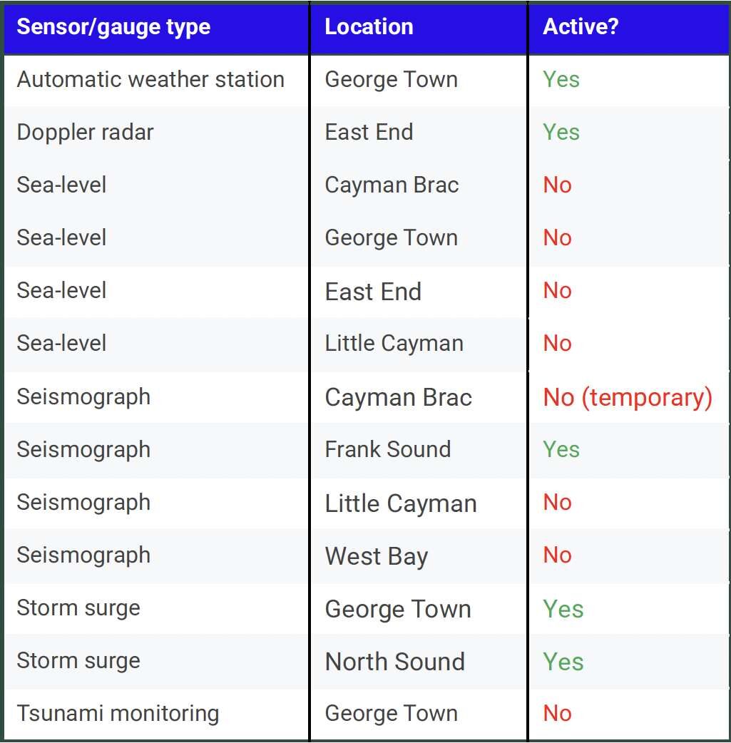
On 18 May 2023, it was discovered that the gauge on Cayman Brac had been destroyed by vandals who stole the antenna, solar panel and marine batteries. It has not been repaired.
The station located in Gun Bay, East End started working on 17 May 2022 and stopped working on 4 July 2024.
The sea-level monitoring station in George Town started transmitting data on 5 Oct. 2022 and stopped providing data on 17 June 2023.
Chief surveyor at Lands and Survey Darren Kelly said, “We received senior management support to reinstate all four sensors in Grand Cayman, Cayman Brac and Little Cayman in the next budget cycle, which starts off in the next calendar year.
“But before we start on that process, we want to have an educational campaign to just let the public know what these sensors are, where they are located, how they serve the public, and really speak to the importance of these installations and how they impact not only Grand Cayman, Little Cayman and Cayman Brac but also our region.”
Tsunami and earthquake monitoring
The Cayman Islands also has a tsunami-monitoring gauge in George Town harbour, which is part of a regional Caribbean tsunami warning network.
If an earthquake generates a tsunami that is detected on the sensor, the data is sent via satellite to the Pacific Tsunami Warning Center in Hawaii and other international scientific institutes.
At the time of installation, Lee Madison of the Department of Public Safety Communications explained, “It constantly monitors the sea level. If the level changed suddenly, it would send an alarm.”
That information is then used by other countries in the region to determine if their own coastlines face a tsunami threat.
This tsunami warning system gauge stopped transmitting data on 7 Oct. 2023. The Compass is waiting to hear back from the Department of Public Safety Communications about whether there are plans to get the tsunami gauge working again and if there is a maintenance budget for its upkeep.
The Department of Public Safety Communications is also in charge of the four seismographs in the Cayman Islands. These instruments measure earthquake shaking.
Two out of four of the seismographs in the network are not working and another in Cayman Brac is temporarily offline pending a reboot. Only the seismograph in Frank Sound is currently operational.
Under the Cayman Islands National Weather Service Act, 2010, the functions of the weather service include “establishing and maintaining a network of seismic stations and issuing tsunami warnings”.
It is not clear at this point if the weather service will take over responsibility for the seismic network and tsunami gauge that is part of the regional tsunami warning system.
Cayman Islands National Weather Service Meteorologist Shamal Clarke recently indicated that this “may depend on whether or not the Cayman Islands National Weather Service becomes a 24/7 operation”.
Storm-surge systems
In 2023, the COMET Program at the University Corporation for Atmospheric Research installed two storm-surge sensors in the Cayman Islands. These low-cost instruments use ultrasonic sensor technology to measure the water level and provide an estimate of sea-level height, which meteorologists can use to provide early warning of increasing storm surge to the community.
At the time they were installed, a social media post mentioned, “The sensors will also help NOAA and the National Hurricane Center to validate its storm surge model and forecasts for Grand Cayman.”
Shortly after the installation, one sensor was struck by lightning and stopped working and the other sensor was damaged in the Nor’wester this year, but both sensors have been repaired are now back up and running.
Director of the Cayman Islands National Weather Service John Tibbetts said there were plans to increase this storm-surge network and they are currently working on the procurement to place sensors on all three Islands.
He added the procurement will also include two inshore weather buoys and the Caribbean Institute for Meteorology and Hydrology has donated an additional three weather buoys to the Cayman Islands Government. These buoys are expected to be installed by early 2026.
The buoys will measure variables like water temperature, wave height, wave length (period), wave frequency, storm surge, water level and wave direction.
Meteorologist Clarke explained that part of the procurement will also include a data platform.
“We will centralize the data from the sensors and while we will use the information internally to help will our weather analysis and forecasting, the platform will also be public facing, so everyone can freely access the information,” Clarke said.
Weather stations
Towards the end of the year, the weather service will also install four automatic weather stations along with four masts: one in West Bay, one in Frank Sound, one in Little Cayman and another in Cayman Brac.
These automatic weather stations will provide additional data on temperature, humidity, UV index, ‘feel like’ temperatures, atmospheric pressure, rainfall, wind speed and wind direction.
When the National Weather Service first announced the plans for the network of automatic weather observation stations, Tibbetts told the Cayman Compass, “Each station would be furnished with equipment for lightning detection and cloud bases – the lowest altitude of the visible portion of clouds – as well as to monitor air quality.”
Currently the National Weather Service has just one automatic weather station, which is located near Jose’s Rubis station on Agnes Way in George Town at the site where the new weather service building will be constructed.
“We hope the building will be complete by middle of next year,” Tibbetts said.
With the exception of two brief outages for scheduled maintenance in December 2024 and in January 2025, the Kearney Gomez Doppler radar has been fully operational since the start of the 2024 hurricane season following a major overhaul by Leonardo, the company that first installed it. Prior to that, there had been three extended outages, including one from 20 Oct. 2023 to 27 May 2024.