


It has been a quiet start to the 2025 Atlantic hurricane season, but that is expected to change this month.
In a media advisory issued by AccuWeather on 31 July, lead hurricane expert Alex DaSilva said, “The second half of this Atlantic hurricane season is forecast to be much more active and volatile than the first half. If influences from a returning La Nina emerge later this year, we could see conditions that are conducive for tropical storm development extending right through late October and November, possibly even into early December this year.”
While no tropical storms or hurricanes are expected to form in the Atlantic basin for a least the next 10 days, atmospheric conditions are becoming more suitable and Accuweather urged increased levels of readiness.
“Do not wait any longer to restock your emergency supplies or check your insurance policies,” he said. “The risk of rapidly intensifying storms in exceptionally warm waters can leave everyone with less time to react, prepare and evacuate.”
Historical numbers
Starting in August, the tropical waves coming off the coast of Africa hold together better and can possibly develop into tropical cyclones. Although the chances are low of a significant impact by a tropical cyclone on any particular place in the Atlantic basin – including the Cayman Islands – the chances are high that a cyclone will impact several places in the basin this year.
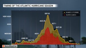
Hurricane season runs from 1 June to the end of November but a significant ramp up in activity tends to begin in August and continues into the middle of October when the number of storms typically start to trend back down. However, between now and the climatological peak of hurricane season on 10 September, historically there has been a sharp rise in the number of named storms and hurricanes.
Despite what seems like a slow start to this year’s hurricane season, DaSilva said that it is currently pacing ahead of the historical average with three named storms so far this year.
“The third named storm of the season typically develops in early August, and the fourth named storm forms around mid-August,” DaSilva said.
For the entirety of the hurricane season, Accuweather continues to forecast 13 to 18 named storms and seven to 10 hurricanes, of which three to five would be major hurricanes of Category 3 or above.
More conducive environment for storms
Several factors make tropical cyclone formation and strengthening more likely now that it’s August.
Tropical waves form due to ‘atmospheric instability’, when warm air generated by the Sahara Desert meets the cooler temperatures and more humid conditions over the forests and waters of the Gulf of Guinea. This contrast in the atmosphere creates disturbances and troughs of low pressure which come off Africa and travel across the Atlantic Ocean, generally in an east-to-west direction towards the Caribbean Sea.
According to the National Hurricane Center, approximately 60% of Atlantic tropical cyclones and 85% of major hurricanes originate from tropical waves. During the summer months, the National Hurricane Center says around 60 tropical waves come off the west coast of Africa.
In the early part of the hurricane season, thunderstorms often associated with tropical waves tend to fall apart because they are affected by the Saharan Air Layer, which is dust that travels in the atmosphere across the Atlantic Ocean towards the Caribbean region. This Saharan dust creates dry air conditions, which removes a lot of the moisture in the atmosphere, inhibiting storm development. The Saharan dust also helps shield the ocean from the sun to a certain degree, keeping the sea surface temperatures lower.
For a tropical storm or hurricane to develop, the National Oceanic and Atmospheric Administration – the US weather service better known as NOAA – says the temperature of the upper 300 feet of the ocean water must be greater than 80 degrees Fahrenheit. Once the Saharan dust lessens, the sun will quickly warm the ocean to the necessary temperature.
Another factor causing the increased chances of tropical cyclone development starting in August involves wind shear.
Tropical waves have to survive the fast upper-level winds, known as wind shear. High levels of wind shear create unfavourable conditions for tropical storm and hurricane development, but according to the National Hurricane Center, around the middle of August, wind shear usually starts to significantly decrease, creating a more favourable environment for storm formation.
“This minimum in the shear combines with favorable thermodynamics – ocean temperatures in the deep tropics that increase with each day of summer sun, warmer air temperatures, and increasing atmospheric moisture,” the National Hurricane Center states. “When the dynamics and thermodynamics are in sync, as they often are from mid-August through early October, disturbances like African tropical waves can easily strengthen.”